About All Tours From Cusco ToursHiking ToursInca Trail ToursFrom Lima ToursPrivate ToursSacred Valley ToursAnd Rainbow Mountain ToursAnd Lake Titicaca Tours2-Day Tours Directions Hours & Fees
Find Tours 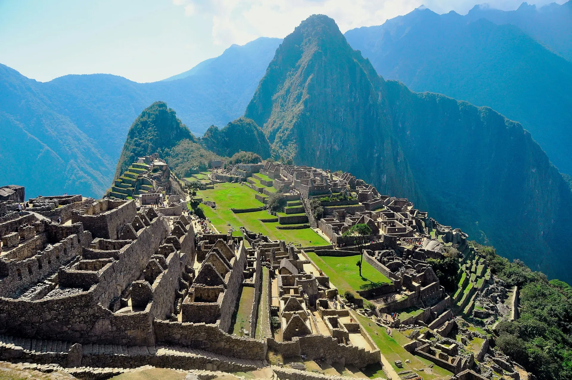
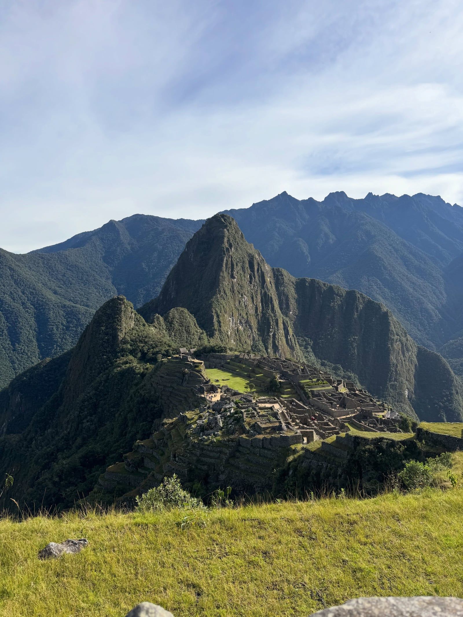
Machu Picchu occupies a magmatic rock ridge 2,430 meters above sea level in the eastern Andes. The 15th-century Inca citadel contains hundreds of stone terraces and temples aligned with astronomical events.
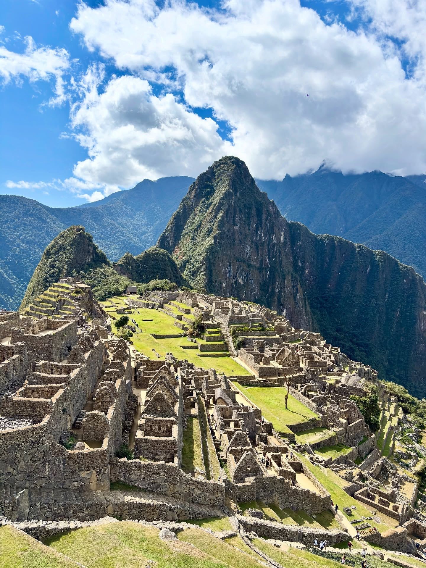
The 15th-century Inca citadel of Machu Picchu covers a mountain ridge 2,430 meters above the Urubamba River in southern Peru. Magmatic rocks of the Vilcabamba Batholith form the foundation for hundreds of stone structures, agricultural terraces, and plazas. The surrounding Historic Sanctuary spans 32,592 hectares of mountain slopes, deep valleys, and cloud forests transitioning into the Amazon Basin. Mist frequently obscures the lower elevations, leaving only the stone ruins and the adjacent peaks of Huayna Picchu and Huchuy Picchu visible from the Guardhouse Viewpoint. Temperatures fluctuate between 8ºC and 28ºC, supporting a humid microclimate that sustains over 420 documented bird species.
Reaching the site requires careful logistical planning. PeruRail and Inca Rail operate trains from Cusco and Ollantaytambo to Aguas Calientes, with round-trip tickets ranging from $140 for standard economy to $600 for luxury services like the Hiram Bingham. Budget travelers often take shared vans from Cusco to the Hidroeléctrica station, followed by a 10-kilometer hike along the train tracks. From Aguas Calientes, a fleet of Consettur shuttle buses departs every 5 to 15 minutes, climbing a steep, winding dirt road for 30 minutes to reach the main entrance.
Visitors navigate steep, uneven stone steps that become slick and hazardous during the November to March wet season. Heavy rainfall frequently triggers travel delays, flooding, and landslides along the railway. The dry season from May to October brings clear skies and firm footing, drawing up to 4,500 daily visitors to the ruins. Access requires booking timed entry tickets linked to specific circuits months in advance through the official government portal. Independent adult tickets cost 152.5 soles, granting a strict 2.5-hour window to walk the designated paths.
Strict regulations protect the archaeological site from structural damage and overcrowding. Guards enforce a maximum bag size of 40 by 35 by 20 centimeters, turning away anyone carrying larger hiking packs. Drones, metal-tipped walking sticks, and tripods face immediate confiscation at the security checkpoints. Illegal drone flights over the ruins carry fines up to $10,000. Visitors must present their original physical passport alongside their printed ticket to gain entry, and exiting the gates to use the restroom immediately terminates the visit.
Inca emperor Pachacuti Inca Yupanqui ordered the construction of the royal estate around 1450. Engineers carved the city directly into the Vilcabamba Batholith, utilizing the natural granite fault lines to quarry building materials directly on site. Laborers moved massive stone blocks up the steep inclines using ramps and sheer human force, operating entirely without wheels or iron tools. Stonemasons shaped these granite blocks to fit together tightly enough to withstand major earthquakes. The resulting complex included religious temples, astronomical observatories, and residential quarters for approximately 750 inhabitants. Deep foundations and complex underground drainage systems made up more than 60 percent of the total construction effort, preventing the heavy mountain rains from washing the city away.
The site operated for less than a century before its residents abandoned it between 1532 and 1565. Spanish conquistadors dismantled the Inca Empire during this period, capturing major cities like Cusco, but they never located the mountain citadel. Jungle vegetation quickly consumed the stone terraces and buildings, hiding the structures from the outside world. The dense cloud forest canopy protected the masonry from Spanish destruction, leaving the temples intact. Local indigenous farmers knew of the ruins and occasionally utilized the ancient agricultural terraces to grow crops. Agustín Lizárraga, a Peruvian tenant farmer, documented his visit to the overgrown site in 1902, leaving his name inscribed on one of the temple walls.
American explorer Hiram Bingham arrived in 1911, guided by local residents Melchor Cobos and Toribio Recharte to the ruins. Bingham published extensive reports and photographs in National Geographic, drawing international attention to the site. He mistakenly believed he had found Vilcabamba, the lost final refuge of the Inca. The Peruvian government later established the 32,592-hectare Historic Sanctuary to protect both the archaeological monuments and the surrounding cloud forest ecosystem. UNESCO designated the area a World Heritage Site in 1983, recognizing its dual cultural and natural value.
Today, preservation efforts focus on managing foot traffic and preventing erosion on the ancient stone pathways. The Ministry of Culture limits daily attendance to 3,800 visitors during the low season to reduce physical wear on the monuments. Specialized companies like Wheel the World now provide all-terrain wheelchairs and trained porters, making approximately 60 percent of the main citadel accessible to visitors with mobility limitations. Standard trains and Consettur buses remain largely inaccessible for standard wheelchairs. Travelers must hire a licensed guide at the entrance gate for approximately $40 to understand the complex history of the individual sectors, as informational plaques do not exist inside the ruins.
Granite walls rise directly from the natural rock formations of the mountain ridge. Inca stonemasons employed ashlar techniques, cutting stones to fit together without mortar. This dry-stone construction allows the rocks to shift during seismic activity and settle back into place, preventing the walls from collapsing. The Temple of the Sun features a semicircular design built over a massive granite boulder, with windows precisely aligned to catch the sun's rays during the winter solstice. Beneath this temple lies a natural cave that archaeologists believe served as a royal mausoleum, featuring finely carved altars and niches.
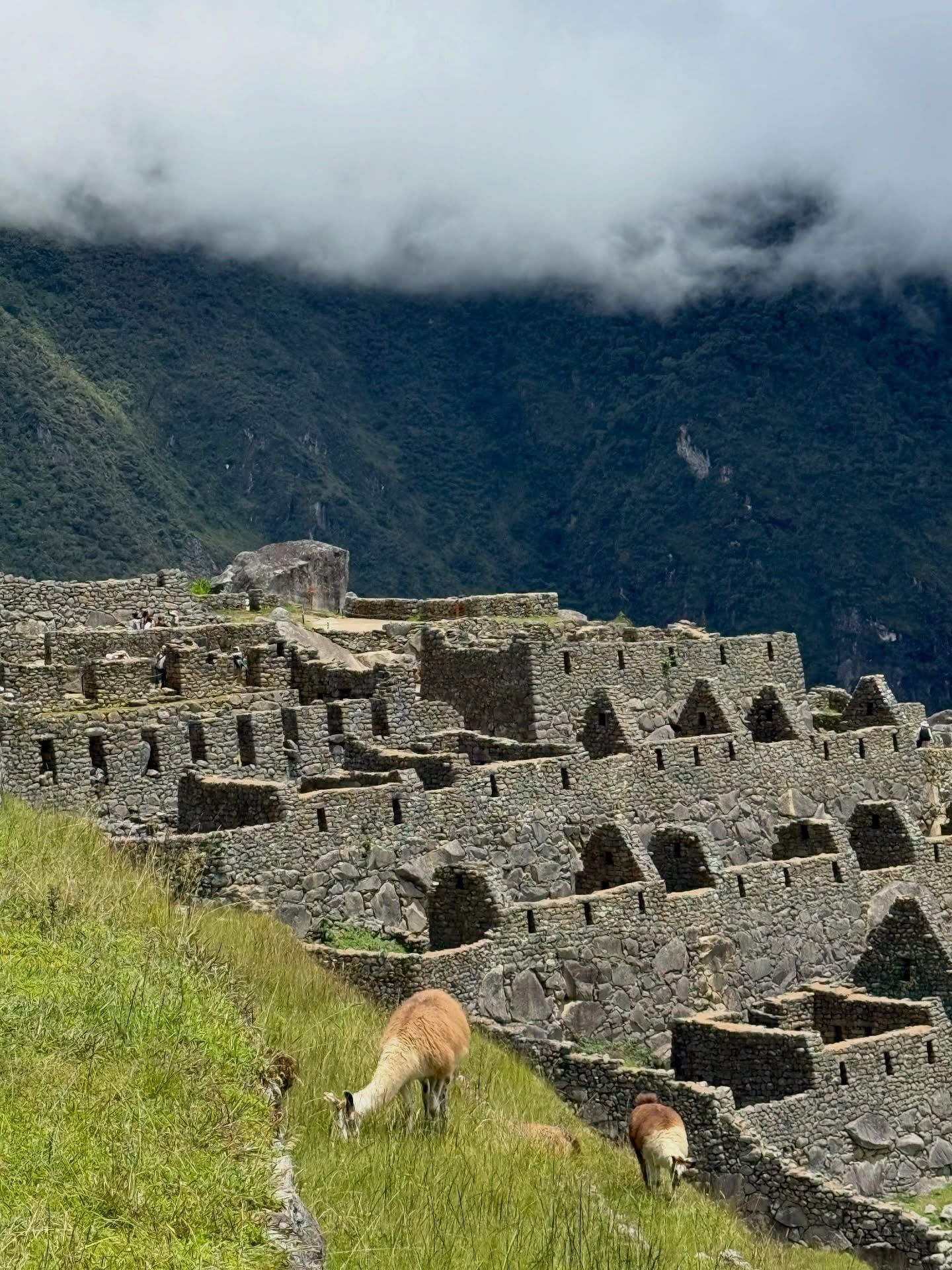
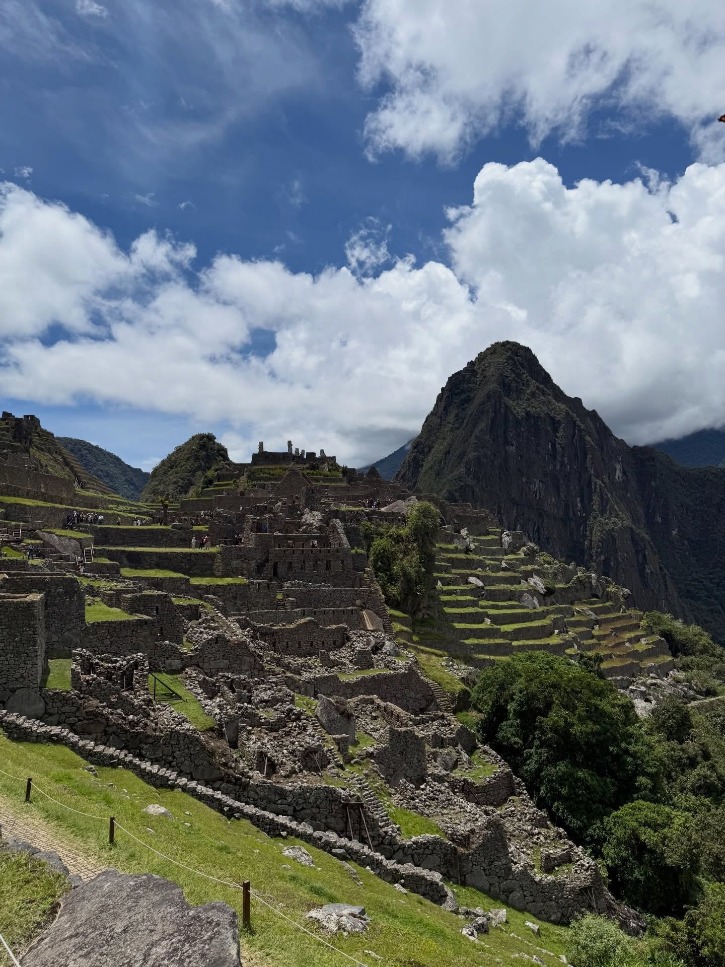
Massive stone terraces cascade down the steep mountain slopes, dropping hundreds of meters toward the Urubamba River. These agricultural structures feature distinct layers of topsoil, sand, and gravel designed to filter heavy rainwater. The drainage system prevents erosion and landslides, stabilizing the entire mountain face. A central grassy plaza divides the urban sector from these farming zones, providing a clear boundary between residential and agricultural activities. Dozens of llamas graze freely on this central lawn, naturally maintaining the vegetation while providing a scale reference for the surrounding architecture.
The Intihuatana stone sits atop a terraced, pyramid-like hill in the urban sector. Carved from a single piece of bedrock, this ritual stone functions as an astronomical clock. Priests used the shadows cast by its central pillar to track the solstices and manage agricultural cycles. Visitors climbing the steep, exposed stone stairs of the adjacent Huayna Picchu mountain gain a direct overhead view of this layout. The ascent requires navigating narrow ledges built into the cliff face, demanding strict attention to footing. A less strenuous alternative, Huchuy Picchu, takes 40 minutes to summit and reaches an altitude of 2,497 meters, offering elevated views without the severe drop-offs.
The Temple of the Three Windows dominates the Sacred Plaza with its massive polygonal blocks. Each of the three large trapezoidal windows looks out over the Urubamba Valley, allowing cool mountain breezes to flow through the structure. The heavy stone lintels above these windows weigh several tons each, demonstrating the precise lifting capabilities of the Inca builders. Adjacent to this structure, the Principal Temple features a three-sided design with a massive stone altar, though its rear wall has visibly shifted over the centuries due to ground settling.
The citadel functions as a physical map of Inca cosmology. Builders aligned major structures with sacred peaks, known as apus, which the Inca believed controlled the weather and agricultural success. The Temple of the Three Windows in the Sacred Plaza represents the three realms of existence in Andean tradition: the celestial world of gods (Hanan Pacha), the earthly world of humans (Kay Pacha), and the inner world of the dead (Uku Pacha). Each trapezoidal window frames a specific view of the Urubamba Valley below, connecting the built environment to the natural landscape.
Modern Andean communities maintain strong spiritual connections to the site. Local shamans and spiritual guides frequently conduct ceremonies in the surrounding valleys to honor Pachamama, the earth mother. The annual winter solstice in June draws particular attention, as the sun's alignment with the temple windows demonstrates the enduring accuracy of Inca astronomical observations. During this period, the shadows cast by the Intihuatana stone align perfectly with the surrounding mountain peaks, marking the beginning of the new agricultural year.
The Manuel Chávez Ballón Site Museum, located a 30-minute walk from Aguas Calientes, houses over 250 recovered artifacts. Copper tools, bronze pins, and ceramic vessels displayed here provide concrete evidence of daily life within the royal estate. Travelers seeking to understand the religious and practical functions of the citadel should examine these artifacts before boarding the $24 Consettur shuttle bus up the mountain. The museum operates from 09:00 to 16:00 and sits near the Mandor Gardens, an ecological oasis featuring cascading waterfalls and butterfly habitats.
The Sacred Valley of the Incas, located two hours away, provides essential context for the citadel. Historic towns like Ollantaytambo preserve original Inca street layouts and massive fortress terraces. Visitors acclimate to the 3,400-meter altitude of Cusco by spending days in these lower valley towns, exploring living Inca traditions before taking the train to Aguas Calientes. The transition from the high-altitude capital to the humid cloud forest of the sanctuary highlights the vast geographic diversity managed by the Inca Empire.
Laborers moved massive granite blocks up the mountain using sheer human force and ramps, entirely without the use of wheels.
More than 60 percent of the site's construction work lies underground, consisting of deep foundations and complex drainage systems.
Dozens of llamas graze freely on the central plaza grasses, helping to keep the vegetation trimmed naturally.
Exiting the main gate to use the restroom terminates your visit, as re-entry is strictly prohibited under any circumstances.
The Peruvian government enforces a strict no-fly zone over the sanctuary, fining illegal drone operators up to $10,000.
Guards confiscate metal-tipped walking sticks at the entrance to prevent damage to the 15th-century stone pathways.
No public roads connect Cusco to Aguas Calientes, forcing visitors to either hike for days or take a specialized train.
The standard adult ticket costs 152.5 soles, or approximately $40 USD. This price covers entry to the designated circuits but does not include a tour guide or the bus ride up the mountain.
The archaeological site opens daily at 06:00 and closes at 17:30. The final entry slot of the day begins at 15:00, and visitors must adhere strictly to their ticketed time.
Hiring a guide is not legally required for entry, though it helps with navigating the complex one-way circuits. Private guides charge around $40 USD for a small group tour at the main gate.
Guards prohibit backpacks and bags larger than 40 by 35 by 20 centimeters. You must leave oversized luggage in the storage lockers located outside the main entrance.
Tripods, selfie sticks, and camera stabilizers are completely banned inside the site to prevent path congestion. Professional photographers need a special permit costing over $300 USD to use a tripod.
The Consettur shuttle bus charges $24 USD for a round-trip adult ticket. Children under 12 qualify for a discounted rate of $12 USD.
The Ministry of Culture caps daily attendance at 4,500 people during the peak dry season from June to October. Capacity drops to 3,800 visitors per day during the wet season.
The ticket office in Aguas Calientes sells up to 1,000 tickets daily for in-person buyers. Securing one often requires queuing early in the morning, so booking online months in advance is safer.
Guards allow a 30-minute grace period during the low season if you arrive late. This tolerance extends to 45 minutes during the high season to account for train or bus delays.
No restrooms exist past the main entrance gate. You must use the facilities outside before scanning your ticket, as re-entry is prohibited once you leave.
Browse verified tours with free cancellation and instant confirmation.
Find Tours